
OS National Geographic Database (NGD)
Introducing the Ordnance Survey National Geographic Database (NGD) from Postcoder. Supercharge your operations with the most comprehensive geodata in Great Britain.

Millions of data points, updated daily
Data points
Describes half a billion geographical features across Great Britain.
Addresses
Provides built, historic, pre-build and street addresses, and non-addressable objects.
Coordinates
Includes property coordinates and grid references.
UPRNs
Provides UPRNs and other key identifiers like the UDPRN and USRN.
Updated daily
Refreshed each day, with changes automatically applied to Postcoder.
OS National Geographic Database (NGD)
Access the NGD and its most comprehensive geodata for Great Britain using Postcoder.
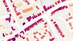
The NGD holds detailed information on over half a billion geographical features across Great Britain. It is the most comprehensive geographic dataset available, covering everything from buildings, addresses and transport networks to land and water, and administrative boundaries.
Designed as a digital mirror of the real world, the NGD provides rich, structured data to support advanced analysis and decision-making. Its scale and precision make it an invaluable resource for organisations looking to understand and interact with the physical landscape more effectively.

Accuracy and volume
The NGD provides unprecedented accuracy and a substantially greater volume of location data. With millions of readily searchable datapoints, it unlocks new possibilities for analysis and insight.
Unlike AddressBase, which was refreshed every six weeks, the NGD is updated daily. This frequent refresh cycle, combined with the greater number of datapoints, creates fresh opportunities for your organisation to innovate with the data.
Competitive advantage
The NGD is already a cornerstone for the UK Government and much of the public sector, underpinning vital systems and services. Organisations across utilities, infrastructure, and energy - as well as countless other industries - are discovering its value.
Ensure your business keeps pace. Whether you work with the UK's addresses, natural landscapes, built assets or administrative boundaries, the NGD offers the intelligence to support smarter, faster decision-making.
Seamless integration
Postcoder is your gateway to the NGD. As an official Ordnance Survey partner, Postcoder delivers the data you need - comprehensively and reliably.
Even better, NGD data is available through Postcoder in the same familiar format as PAF or AddressBase, ensuring seamless integration with your existing systems and platforms.

Everything your business needs
Postcoder and its team of address and technology specialists meet the needs of high-demand applications and rapidly growing businesses.
ISO 9001 certified
Built on quality management best practices you can trust.

Auto-scaling infrastructure
Seamlessly handles enterprise volumes and traffic spikes.
PCI-DSS & GDPR compliant
Designed for secure, privacy-first data handling.
99.99%+ uptime
Proven reliability to keep your integrations running smoothly.
24/7 internal response team
Our engineers are on standby 24/7 to respond to service disruptions.
Low-latency response times
Fast, reliable API performance at all times, even under load.
Full API access & integrations
Connect easily with your existing tech stack.
Truly global coverage
Fast and accurate address autocomplete across all 249 countries.
Dedicated onboarding specialist
Personalised setup and best-practice guidance.
Migration assistance included
Smooth transition from legacy systems or providers.
Free multi-channel support
Get help via chat, email or phone - at no extra cost.

Award-winning with top performance, easy admin and great support
Businesses rate Postcoder 4.7 stars out of 5 on the world's most trusted software marketplace.


"Having a more simplified checkout page with the help of Postcoder has had two major benefits to our business. Faster checkouts by customers who haven't had to type in their full address, a much simpler customer journey and a major reduction in data errors; where we saw a big drop in incorrect details entered."
Alex Woods Digital Marketing Executive / Victorian Plumbing
"We picked Postcoder because the API is simple to use and it supports many countries which we want to scale out to."
David Annez Head of Engineering / loveholidays
"The reason we like Postcoder is that the rooftop lat/long coordinates have proven to be far more accurate than any other service and Postcoder has hugely increased our successful delivery rates."
Laura Bailey E-commerce Product Manager / Pasta Evangelists
"Postcoder offers a seamless integration with our services. It is very popular with our customers."
James Gutterson Commercial Manager / Signicat
"Postcoder has been great; there has been a noticeable quality increase in our campaigns. In some the pickup rate went from 30% to 60-70% and our appointment ratings for a campaign went from a 15% average to 40% for one client!"
Daniel Jones IT Technician / Lead Pronto
"Postcoder is a single API that provides all the features we need... Rather than integrate several APIs, we only had to integrate one."
Carl Horn Head of Digital Servicing & Customer Transformation / Capquest
"Postcoder ensures that all the address data, the mobile number and the email addresses that our customers give us are correct. It really speeds up the process for our customers."
Julie Taylor Operations Director / Barrhead Travel